

14 Days
Daily Tour
10 people
___
The Langtang Valley to Sundarijal Trek starts and ends in Kathmandu without retracing a single step. Most treks in Nepal force you to walk back through the same landscape. Here, you move from high alpine wilderness to sacred lakes, cross a challenging pass, and finish in subtropical forests just outside the capital. This 14-day journey with Kalapatthar is planned for safety, comfort, and a genuine Himalayan experience.
Daily health monitoring is a core feature of this package. Your guide checks your oxygen levels, pulse, and temperature every morning before breakfast. You also receive weather reports and detailed briefings about the next day’s trail. This ensures you move safely through high altitude sections, including Laurebina La Pass at 4,610 metres.
Along the trail, you pass through traditional villages shaped by Tibetan Buddhism. Ancient monasteries, prayer flags, and stone settlements reflect the deep-rooted culture of local communities. A major highlight is the connection near Laurebina La, where you enter the sacred Gosaikunda region. These alpine lakes are holy to both Hindus and Buddhists, adding spiritual meaning to the trek.
Compared to more commercial routes in Nepal, this trail remains quiet and peaceful. You get an authentic Himalayan experience without the crowds of Everest or Annapurna.
Last Updated: April 2026, for Spring 2026 and Autumn 2026 departures
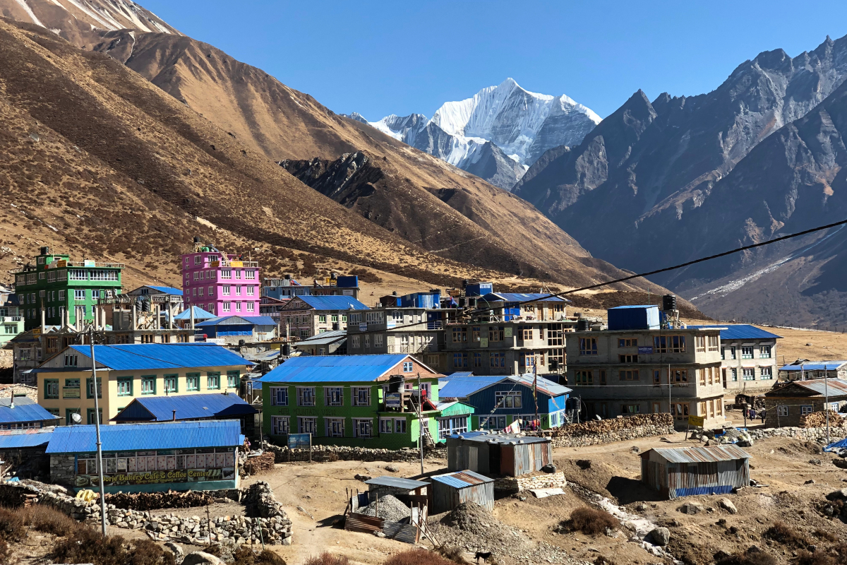
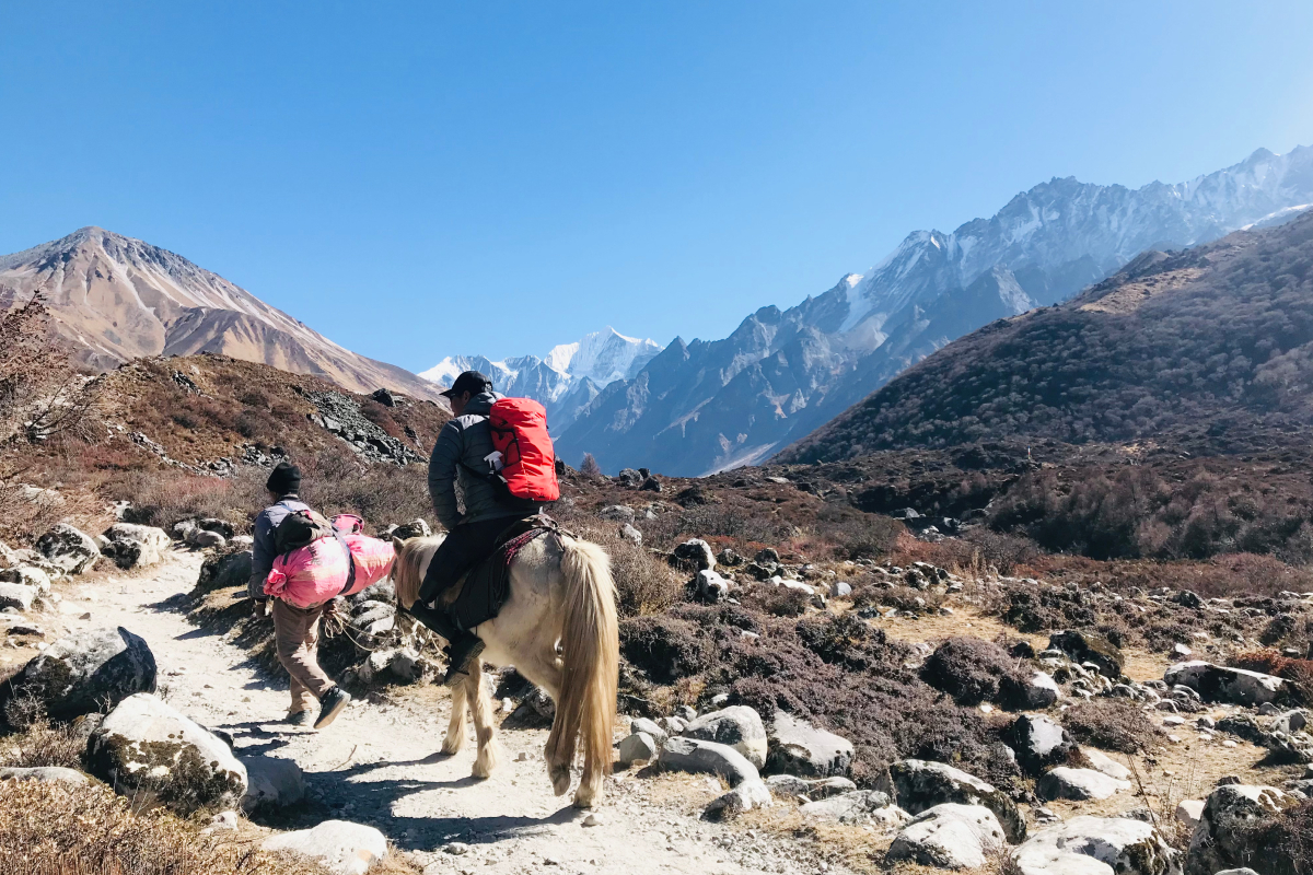
Your adventure begins with a scenic drive from Kathmandu to Syabrubesi. The journey covers about 137 kilometres and takes 7 to 9 hours. You pass through the lush Trishuli River valley, terraced farmland, and traditional hillside villages. On clear days, you catch glimpses of Ganesh Himal and Manaslu.
From Syabrubesi, the trail follows the Langtang Khola through thick forests of rhododendron, pine, and bamboo. You gradually ascend into the heart of Langtang National Park.
The region is home to the Tamang and Sherpa people. Their language, architecture, food, and religious practices carry strong Tibetan influence. You pass through Langtang Village, which was severely damaged in the 2015 earthquake. The community has rebuilt on safer ground, and the ruins of the old village remain as a memorial. Trekking here means witnessing survival and rebuilding.
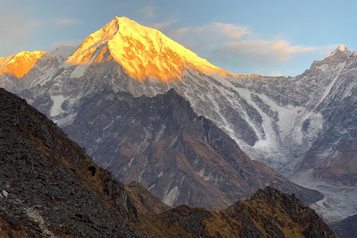
Continuing upward, you reach Kyanjin Gompa at 3,870 metres. This is the spiritual and cultural heart of the Langtang Valley. You visit the ancient monastery and the local yak cheese factory. An optional hike to Kyanjin Ri at 4,773 metres or Tserko Ri at 4,984 metres offers stunning views of Langtang Lirung (7,227 metres), Gangchempo (6,778 metres), and the Ganesh Himal range.
Also Read: Annapurna Base Camp Trek via Kalapatthar Trek & Expedition Pvt. Ltd.
From Kyanjin Gompa, the route descends briefly before climbing toward the Gosaikunda plateau. You pass through Sing Gompa, also known as Chandanbari, a small settlement with a monastery and cheese factory. This area is known for medicinal herbs and the red panda habitat.
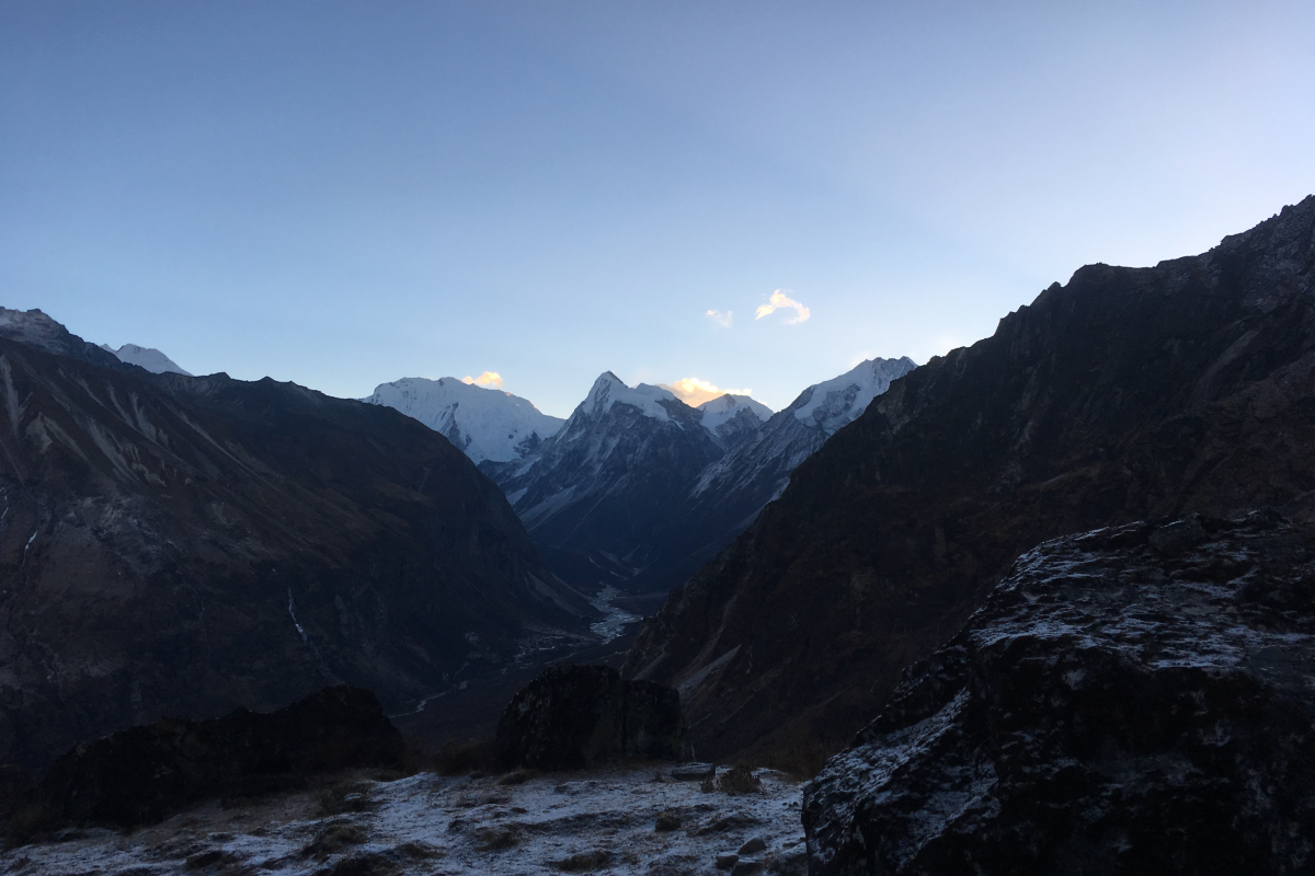
Then comes the high ridge. You cross Laurebina La Pass at 4,610 metres. This is the physical and emotional centrepiece of the trek. From the top, you see both the Langtang Valley and the Gosaikunda plateau spread out below you. From the pass, you descend toward the Helambu region. The landscape transforms from alpine meadows and rocky moraines to dense oak and rhododendron forests, then to subtropical jungle with waterfalls and terraced rice fields.
The trek ends at Sundarijal, a popular watershed and picnic spot on the northern edge of the Kathmandu Valley. A short drive brings you back to the capital. You have completed a full circuit without ever retracing your steps.
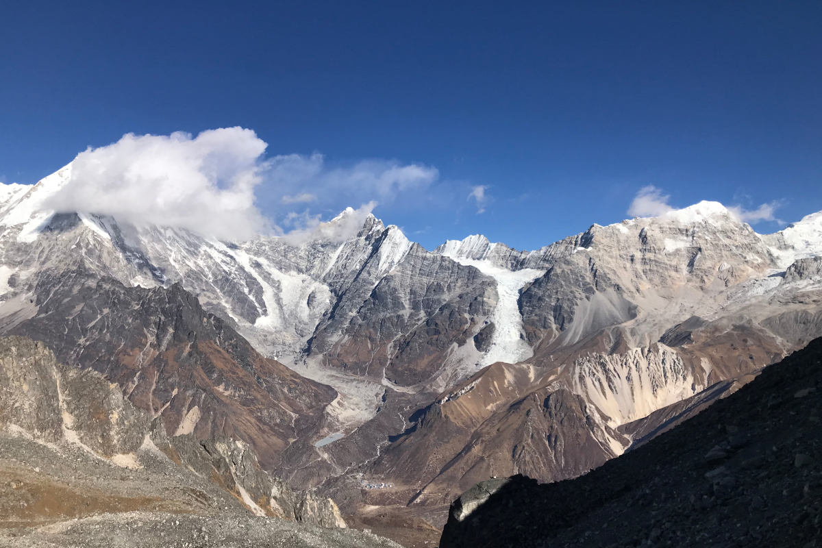
The trek passes through three distinct geographic and cultural zones: the Langtang Valley, the Laurebina La high ridge and Gosaikunda plateau, and the Helambu region. Langtang Valley is called the Valley of Glaciers, named after a legend where a lama followed a runaway yak, with Langtang Lirung at 7,227 metres dominating the skyline. The route connects to the sacred Gosaikunda lake system at 4,380 metres, a complex of 108 lakes where Hindu mythology says Lord Shiva created the main lake with his trident, and pilgrims bathe here during the August festival of Janai Purnima.
Laurebina La Pass at 4,610 metres serves as the boundary between the Gosaikunda basin and the Helambu valley system. Unlike almost every other trek in Nepal, this route begins in the high Himalaya and ends in the subtropical foothills without repeating any section of trail, with each day bringing a completely new landscape. Langtang National Park covers 1,710 square kilometres and is home to over 1,000 species of flowering plants including the rare blue Himalayan poppy, along with red pandas, Himalayan black bears, and over 250 bird species.
The Sundarijal section lies within Shivapuri Nagarjun National Park, which protects Kathmandu’s watershed, and the trail ends at a historic dam and water treatment facility from the Rana era.
The trek passes through four distinct ecological zones. Each zone supports unique plant and animal life.
Subtropical Zone from Sundarijal to Chisapani at 1,350 to 2,200 metres
This zone has sal forests, giant ferns, and oak trees. The trail is lush and green with waterfalls and streams. Common wildlife includes langur monkeys, leopard cats, and occasionally the Himalayan black bear. Birdlife is abundant with kingfishers, eagles, and many songbirds.
Temperate Zone from Chisapani to Tharepati and Thulo Syabru at 2,200 to 3,200 metres
Rhododendron forests dominate this zone. Peak blooms in March and April turn the hillsides brilliant red, pink, and white. The forests mix with oak, maple, and hemlock. This is one of the best areas in Nepal to spot the rare red panda. Early morning walks near Sing Gompa offer the highest chance. You will also see Himalayan thrush, pheasants, and the Himalayan Monal, known as Danphe, which is Nepal’s national bird.
Alpine Zone from Sing Gompa to Laurebina La Pass and Gosaikunda plateau at 3,200 to 4,610 metres
Vegetation becomes sparse with juniper scrub, mosses, and seasonal alpine flowers. The rare blue Himalayan poppy, scientifically known as Meconopsis grandis, blooms between 3,200 and 4,000 metres during July and August. Medicinal herbs such as yarsagumba, the caterpillar fungus, are collected here. This fungus can fetch prices higher than gold per kilogram. Wildlife includes blue sheep, known as bharal, Himalayan griffon vultures, and very rarely, the snow leopard.
Glacial Zone from Kyanjin Gompa to Langtang Valley at 3,800 to 4,500 metres
This upper section is characterised by glacial moraines, ice falls, and rocky terrain. Hardy plants like lichens and cushion plants survive in sheltered areas. Wildlife is limited to blue sheep and occasionally the elusive snow leopard. The views of Langtang Lirung and the surrounding glaciers are the main attraction.
The Langtang Valley to Sundarijal Trek is moderate to challenging. You walk 5 to 7 hours daily under normal conditions. The Laurebina La Pass crossing takes 7 to 8 hours.
Key difficulty factors
Your guide monitors oxygen saturation and altitude sickness symptoms every morning before breakfast. Weather reports are provided consistently. The itinerary is fully flexible, allowing extra rest or acclimatisation days if needed. The rest day at Kyanjin Gompa on Day 7 is particularly important for adjusting to altitude before the pass.
The best time for this trek is during spring and autumn, when weather conditions are most stable, and mountain views are clearest.
Spring from March to May: Spring offers clear skies, comfortable temperatures, and vibrant rhododendron blooms. Daytime highs at higher elevations range from 10 to 15 degrees Celsius. April is the most favourable month. Laurebina La Pass is generally accessible.
Autumn from September to November: Autumn brings dry trails and crystal clear views after the monsoon. October offers the best visibility. November has quieter trails with colder nights. Stable weather makes this ideal for crossing the pass.
Winter from December to February: Winter trails are quiet but harsh. Nighttime temperatures drop to minus 10 or minus 15 degrees Celsius above 3,500 metres. Snow may block Laurebina La Pass. Recommended only for experienced trekkers with proper gear.
Monsoon from June to August: Monsoon brings lush green landscapes and the rare blue Himalayan poppy. However, trails are slippery with leeches at lower elevations. This season coincides with the Gosaikunda pilgrimage in August, offering a unique cultural experience for those who do not mind rain.
The Langtang Valley to Sundarijal Trek itinerary is built on a simple principle: move safely, acclimatise properly, and experience the full diversity of the Himalayan landscape without backtracking. Unlike standard treks that force you to walk out the same way you came in, this route forms a complete circuit from the high altitude glaciers of Langtang to the subtropical forests of Sundarijal. Every day is planned around a balanced walking duration of 5 to 7 hours, with a shorter day before the key acclimatisation stop and a longer day reserved for the Laurebina La Pass crossing.
Your safety is supported by a daily morning health checkup, where your guide measures oxygen saturation, pulse rate, and temperature before breakfast. Weather reports and route briefings are provided each morning and evening, ensuring you are fully informed about trail conditions and altitude considerations. Unlimited food, 100 per cent safe boiled drinking water, tea, and coffee are served throughout the trek, and a paramedic-trained guide remains with you from start to finish.
The itinerary is fully flexible. If you need an extra rest day at Kyanjin Gompa or Sing Gompa, it can be added at no additional land cost. If weather conditions make the pass crossing unsafe, the schedule adjusts accordingly. You are not a prisoner to a fixed calendar. This is your trek, and the only priority is completing it safely and successfully while experiencing the glaciers of Langtang, the sacred Gosaikunda plateau, and the green forests of Sundarijal.
Packing properly for this trek makes a huge difference in your comfort and safety. You will walk through everything from subtropical forests to a 4,610 metre high pass, so the weather can change quickly. The key is to pack smart, not heavy.
Clothing follows a simple three-layer system. The base layer manages moisture, so choose thermal tops and bottoms made of merino wool or good quality synthetic fabric. Merino wool is best because it stays warm even when damp and resists odours. Carry two to three sets. The mid layer provides insulation.
A fleece jacket works well for active walking, but you also need a down jacket rated to at least minus 10 degrees Celsius for the pass crossing and cold mornings. The outer layer protects you from wind, rain, and snow. A waterproof and windproof hardshell jacket and pants are essential, especially on the exposed sections of the Laurebina La Pass.
Accessories are small but critical. Pack a warm beanie, a sun hat with neck protection, thermal inner gloves, and waterproof outer gloves. A neck gaiter or buff helps against the wind and cold. Do not forget UV-protected sunglasses with side shields. The sun reflecting off snow at high altitude can cause snow blindness within hours.
Footwear needs serious attention. Invest in high-quality, waterproof trekking boots with strong ankle support. Break them in before you arrive in Nepal to avoid blisters. Gaiters are highly recommended for the pass crossing and any snowy sections. Bring four to five pairs of merino wool socks. Wool keeps your feet warm even when damp.
You will use a two-bag system. Your main duffel bag of 60 to 70 litres is carried by a porter with a weight limit of 12 kilograms. This bag holds your bulk items like clothing and your sleeping bag. Your daypack of 25 to 35 litres stays with you and carries water, snacks, extra layers, your camera, medications, and toilet paper.
Health and safety items are non-negotiable. Pack a small first aid kit with blister care, antiseptic, and pain relief. Your guide carries advanced medical supplies, but you want your own for minor issues. If you plan to use Diamox for altitude sickness prevention, talk to your doctor first. Sun protection is critical at altitude, so bring SPF 50-plus sunscreen and lip balm. Hand sanitiser and wet wipes keep you clean where there is no running water. Carry all your personal medications in full supply because you will not find them on the trail.
Trekking poles and a headlamp will save you trouble. Poles reduce knee strain on long descents and improve balance on uneven trails. A headlamp is essential for early morning starts, especially on the day you cross the Laurebina La Pass. Carry extra batteries because cold temperatures drain power quickly.
You May Also Prefer Reading: People of Nepal: Bahun
Water is taken care of, but bring your own bottles. You need a minimum capacity of 2 litres. Both water bottles and hydration bladders work fine. A thermos is also nice for carrying hot tea or water on cold sections. Your package includes 100 per cent safe boiled drinking water, but carrying purification tablets as a backup is never a bad idea.
Electronics need extra planning. Camera batteries drain much faster in cold weather. Carry extras and keep them in an inner pocket close to your body. A power bank of 10,000 to 20,000 mAh is essential because the teahouse electricity is limited, slow, and often costs extra.
Sleeping gear matters more than you think. A sleeping bag rated to minus 10 or minus 15 degrees Celsius is essential for nights above 3,500 metres. Teahouse blankets are thin and not enough on their own. A sleeping bag liner adds warmth and keeps your bag cleaner.
Documents and money are easy to forget. Your passport needs at least six months of validity from your arrival date. Keep it in a waterproof pouch. Bring four to six passport-sized photos for your trekking permits. Travel insurance is mandatory and must cover high altitude trekking up to 5,000 metres, including helicopter evacuation. Finally, carry enough Nepalese cash from Kathmandu. There are no ATMs on the trail. You will need cash for charging devices, WiFi, hot showers, snacks, and tips.
Renting gear in Kathmandu is easy. You can rent down jackets and sleeping bags from Kalapatthar before the trek starts. Just inspect the quality and warmth carefully before you head out. Good gear at high altitude is not something to guess on.
The Langtang Valley to Sundarijal Trek is a complete Himalayan circuit unlike any other in Nepal. You start in deep alpine wilderness, cross the sacred Laurebina La Pass at 4,610 metres, and finish in the lush subtropical forests of Sundarijal without ever retracing a single step. With Kalapatthar Trek & Expedition Pvt. Ltd., you are supported by experienced guides, daily morning health checkups, unlimited food and safe drinking water, and a fully flexible itinerary designed for your safety and comfort.
If you are looking for beautiful landscape contrasts, spiritual depth, ethnic Tamang and Tibetan Buddhist culture, and peaceful trails away from the crowds of Everest and Annapurna, this trek is one of the best options in Nepal. You will stay in traditional teahouses, witness ever-changing views from glaciers to waterfalls, and return to Kathmandu with memories that last a lifetime.
For Further Inquiries and Bookings, Please Contact Us directly.
Let us help you take the first step toward experiencing the glaciers of Langtang, the sacred heights of Laurebina La, and the green forests of Sundarijal in a single, unforgettable circuit.
Upon arrival at Tribhuvan International Airport, you are warmly welcomed and transferred to a 5-star hotel in Kathmandu. In the evening, a welcome dinner is hosted along with team introduction and a detailed trek briefing covering route overview, safety protocols, rescue procedures, first aid, emergency contacts, gear checklist, and daily health monitoring. A basic health assessment, including oxygen, pulse, and temperature check, is conducted before dinner.
Today is dedicated to final preparations and gear verification with your trekking guide at the hotel. Any missing equipment can be rented or purchased in Thamel with guide's assistance. A full briefing on route details, safety procedures, and health protocols is provided. All permits and paperwork are finalised, and daily health check routines for the trek are explained.
A 7 to 9 hour drive of approximately 137 kilometres follows the Trishuli River through hills, farmland, and forests with distant views of Ganesh Himal and Manaslu. You arrive in Syabrubesi by late afternoon and settle into a local teahouse. A short briefing covers the next day's trekking plan and weather update. Overnight in Syabrubesi.
The morning begins with a health checkup where your guide measures oxygen saturation, pulse rate, and temperature, followed by a weather report and route briefing. The 5 to 6-hour trek begins through lush forests of rhododendron, oak, and bamboo, crossing suspension bridges over the Langtang Khola. Unlimited food, tea, coffee, and safe boiled water are served throughout the day. You reach Lama Hotel, a small settlement nestled in the forest. An evening briefing covers the next day's trail. Overnight in Lama Hotel.
After a morning health check and weather update, the trail climbs steadily through forest to Ghoda Tabela, a former horse stable that now serves as a Langtang National Park checkpoint. Beyond this point, the valley opens, and you see the first clear views of Langtang Lirung. After 5 to 6 hours, you arrive at Langtang Village, rebuilt on safer ground after the 2015 earthquake. An evening safety briefing is provided. Overnight in Langtang Village.
The morning begins with a health checkup with extra attention given as you gain altitude, followed by a weather report and route briefing. A shorter 3 to 4 hour trek follows a gradual valley ascent past yak pastures and ancient mani walls with Langtang Lirung dominating the skyline. Unlimited food, tea, coffee, and safe boiled water are served. You reach Kyanjin Gompa, the highest permanent settlement in the valley, with time to explore the monastery and yak cheese factory. Evening briefing covers tomorrow's acclimatisation day. Overnight in Kyanjin Gompa.
The morning begins with a thorough health checkup, as this rest day is essential for proper acclimatisation before higher altitudes, followed by a weather report. You can sleep in, rest, or join an optional morning hike to Tserko Ri at 4,984 metres or Kyanjin Ri at 4,773 metres. The hike to Tserko Ri takes 4 to 5 hours round trip and offers the best mountain views of the entire trek, including Langtang Lirung at 7,227 metres and Gangchempo at 6,778 metres. Unlimited food options and safe boiled water are served throughout the day. In the evening, your guide reminds you to drink plenty of water and report any symptoms immediately, and provides a detailed briefing for the days ahead, including the upcoming pass crossing. Overnight in Kyanjin Gompa.
After a morning health checkup and weather update, you descend back through Langtang Village and forested trails to Lama Hotel. The 5 to 6-hour downhill trek helps recovery from altitude. Unlimited food, tea, coffee, and safe boiled water are served. An evening briefing introduces the change in route direction toward the Gosaikunda region. Overnight in Lama Hotel.
The morning begins with a health checkup, followed by a weather report and route briefing. Today, the trail diverts toward the Gosaikunda region, passing through forests and small Tamang settlements. The 5 to 6-hour walk includes steady climbs and scenic ridge views. You arrive in Thulo Syabru, a culturally rich village built on a steep hillside with narrow stone alleys and a large monastery. An evening briefing covers tomorrow's trail and altitude gain. Overnight in Thulo Syabru.
The morning begins with a health checkup with close attention as you gain altitude again, followed by a weather report and route briefing. A 4 to 5-hour uphill trek through dense rhododendron and bamboo forest, an area known for red panda sightings. The forest gradually thins as you reach Sing Gompa, also known as Chandanbari, a small settlement built around a monastery and cheese factory, known for medicinal herbs. Unlimited food and safe drinking water are served. An evening briefing focuses on the upcoming high pass crossing, including weather assessment and health checks. Overnight in Sing Gompa.
The morning begins with the most critical health check of the entire trek, including detailed questions about headache, nausea, dizziness, and sleep quality, followed by a final weather report and route briefing. A pulse check measuring oxygen, temperature, and heartbeat is conducted. If readings are concerning or symptoms are reported, the guide will recommend resting an extra day or descending. You wake before sunrise and climb steeply above Sing Gompa toward the Laurebina ridge. The landscape becomes barren and rocky as you enter the Gosaikunda lake region trail system. The ascent from the Gosaikunda lakeside area to the pass climbs approximately 230 metres. At the 4,610 metre pass, prayer flags mark the crossing. The descent is steep with loose scree sections. Weather monitoring and safety checks are continuous throughout the 7 to 8-hour trek. After crossing the pass, you follow a winding trail down to Ghopte, the most remote night of the trek. Upon arrival, your guide performs a brief health check to ensure no delayed symptoms. Unlimited food and safe boiled water are served despite the remote location. An evening briefing covers tomorrow's descent. Overnight in Ghopte.
ered from yesterday's long day, followed by a weather report and route briefing. A 4 to 5 hour trek through ridges and forested trails with clear views of the Ganesh Himal range. You leave the alpine zone and enter upper temperate forests, passing through small settlements and yak pastures. Unlimited food, tea, coffee, and safe boiled water are served. You reach Tharepati, a ridge-top settlement. An evening briefing covers tomorrow's trail into the Helambu region. Overnight in Tharepati.
The morning begins with a health checkup, followed by a weather report and route briefing. A 5 to 6 hour descent through forests of oak and rhododendron in the Helambu region, where villages have a mix of Tamang and Sherpa culture. The trail follows ridgelines with views of the lower hills and, on clear days, the distant Himalayas. Unlimited food and safe drinking water are served. You reach Chisapani, a small settlement perched on a ridge. An evening briefing covers tomorrow's final day of trekking. Overnight in Chisapani.
The morning begins with the final health check of the trek, followed by a weather report and route briefing. A pulse check measuring oxygen, temperature, and heartbeat is conducted, and your successful completion of the circuit is recorded. A 3 to 4 hour final descent through Shivapuri Nagarjun National Park, which protects the watershed for Kathmandu, following a series of waterfalls and streams through subtropical forest with giant ferns and sal trees. Unlimited food, tea, and coffee are served on this final day. You reach Sundarijal, a picnic spot and location of a historic dam and water treatment facility. A private vehicle meets you for the one-hour drive back to Kathmandu, where you check into your 5-star hotel. Your guide provides a final debriefing, and a farewell dinner is arranged to celebrate your successful completion of the Langtang Valley to Sundarijal Trek.
Yes, with proper preparation. The trek is rated moderate to challenging. First-time trekkers with good physical fitness, no pre-existing health conditions, and a willingness to follow acclimatisation guidelines can complete this trek successfully. Previous trekking experience above 3,500 metres is recommended but not mandatory. Booking with a professional guide, like Kalapatthar, significantly increases your safety and success rate.
The pass crossing on Day 11 is the most challenging section of the trek. You ascend from approximately 3,330 metres at Sing Gompa to 4,610 metres at the pass, then descend to 3,430 metres at Ghopte. The walking day lasts 7 to 8 hours. The terrain includes steep sections, loose scree, and potentially snow or ice depending on the season. No technical climbing is required. Good physical fitness, proper acclimatisation, and an early start are essential. Your guide will assess your condition during the morning health checkup before allowing you to attempt the pass.
Yes, travel insurance is mandatory. Your policy must cover high altitude trekking up to 5,000 metres and include emergency helicopter evacuation, medical expenses, trip cancellation, and lost baggage. Kalapatthar does not sell insurance, but we can recommend reputable providers such as World Nomads, SafetyWing, or AXA. You must provide proof of insurance before the trek begins.
Your guide performs daily morning health checkups to detect early signs of altitude sickness. If symptoms appear, the guide will first advise rest, hydration, and medication such as Diamox if appropriate. If symptoms persist or worsen, the guide will arrange descent to a lower altitude immediately. Descent is the only reliable treatment for moderate to severe altitude sickness. Your guide carries a first aid kit with high altitude medications and coordinates emergency evacuation if required. All guides are paramedic trained and experienced in recognising and responding to altitude-related illnesses.
Yes, but with limitations. Most teahouses have electricity for charging, typically using solar panels or hydro power. Charging is not free. Expect to pay USD 1 to 3 per device per charge at higher elevations. Charging facilities are more reliable and less expensive at lower elevations. We strongly recommend carrying a power bank of 10,000 to 20,000 mAh to keep your devices charged between teahouses.
Mobile phone coverage is available in some sections, but not consistently. Ncell and Nepal Telecom provide the best coverage. You can expect a signal in Syabrubesi, Langtang Village, Kyanjin Gompa, and Thulo Syabru. There is no signal on the pass crossing day or in the remote sections between Ghopte and Chisapani. WiFi is available at most teahouses for a fee, typically USD 2 to 5 per hour, but speeds are slow, and connections are not reliable.
Teahouses have shared toilet facilities. At lower elevations, toilets are typically western-style flush toilets. At higher elevations, especially above 3,500 metres, toilets are more basic. Some are squat toilets. Toilet paper is not always provided, so carry your own. Hand sanitiser is essential as soap and water may not always be available.
Yes, but with conditions. At lower elevations, hot showers are available for a fee of approximately USD 2 to 5. At higher elevations above 3,500 metres, showers are not recommended because the cold temperatures increase the risk of illness. Most trekkers use wet wipes or wash with warm water in their room instead of taking full showers at altitude. Your guide will advise you on when showers are safe.
Kalapatthar maintains a maximum group size of 6 trekkers. This small group size ensures personalised attention from your guide, faster decision-making, and better care. Private treks with a solo guide are also available at an additional cost.
Each porter carries a maximum of 12 kilograms. This is the standard limit set by the Trekking Agencies Association of Nepal to protect porter welfare. Your main duffel bag should not exceed 12 kilograms. You carry a daypack of 25 to 35 litres with your daily essentials. If you need to carry more than 12 kilograms, we can arrange an additional porter at extra cost.
You need two permits. The Langtang National Park Permit costs approximately USD 23 to 25. The TIMS card costs approximately USD 8 to 17. Both permits are arranged by Kalapatthar as part of the package. You simply need to provide a copy of your passport and two passport-sized photographs.
Yes. Nepal is generally safe for solo female travellers, and Kalapatthar has extensive experience guiding solo female trekkers. You will be assigned a professional guide who stays with you throughout the trek. Teahouse accommodation is basic but safe. We recommend booking a private room for additional privacy. Many solo female travellers complete this trek each year without issues.
Independent trekking is legal in Nepal, but we strongly recommend against it for the Langtang Valley to Sundarijal Trek. The route is not as well-marked as the Everest or Annapurna regions, especially on the less-travelled sections between Gosaikunda and Helambu. The Laurebina La Pass crossing requires navigation in potentially poor weather. Mobile phone signal is not reliable. Your guide also provides daily health checkups, which are essential for safety at altitude. For your safety, go with a guide.
You can cancel your booking up to 30 days before the trek departure date for a full refund minus any bank transaction fees. Cancellations between 30 and 15 days before departure receive a 50 per cent refund. Cancellations within 14 days of departure receive no refund. If Kalapatthar cancels the trek due to weather, natural disaster, or other safety concerns, you receive a full refund or can transfer to a future departure date.
Tipping is customary in Nepal and reflects your satisfaction with the service. There is no fixed amount, but guidelines are common. For a 14-day trek, typical tips are USD 10 to 15 per day for the guide and USD 5 to 8 per day for the porter. Tip amounts can be adjusted based on the quality of service and your budget. Tipping is done at the end of the trek.
Member Since 2026
Leave a review